OSM Extracts by Interline
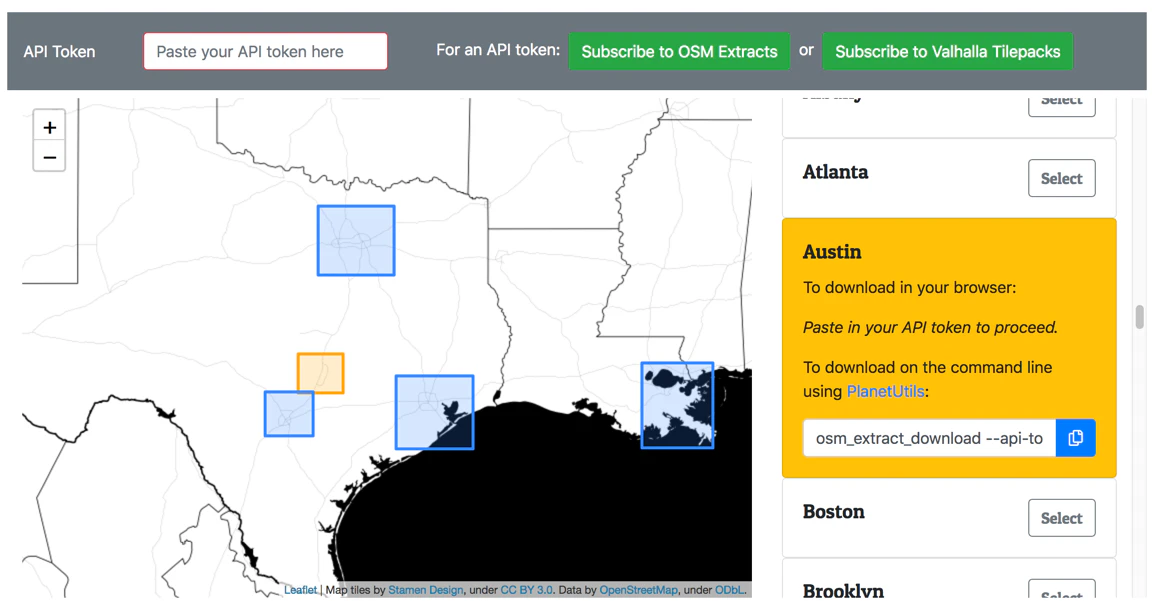
Download OpenStreetMap data for your city. Updated daily.
OSM Extracts by Interline launched on May 24, 2018 with 5 votes. The site was still online in September 2026, 8 years on.
What it does
Each day, OSM Extracts by Interline mirrors the entire OpenStreetMap planet and creates city and region sized extracts. The perfect size to run your own regional routing engine, to generate your own map tiles, or to build your own creation (using QGIS or other GIS software).
Open OSM Extracts is inspired by Michal Migurski's Extractotron and Mapzen's Metro Extracts. Both are now defunct, but we've learned from them and built their best aspects into PlanetUtils (the open-source library that powers OSM Extracts). See Also Need OSM data for entire countries or continents? Try Geofabrik's extract service . Need OSM data in DXF format to use in AutoCad or similar design software? Try Cadmapper . LearnOSM has a guide to even more ways to get OSM data . Not finding the particular city or region you are hoping for? You can open a pull request to propose a new region be added to the GeoJSON file on GitHub . May 14, 2018 : OSM Extracts by Interline are free during the…from app.interline.io
Does a similar job
all alternatives →- OOOpenFreeMap – Open-Source Map Hosting2024 · openfreemap.org · ▲848
Hi HN, After 9 years of running my own OpenStreetMap tile server infra for MapHub (https://news.ycombinator.com/item?id=11389989), I've open-sourced it and launched OpenFreeMap. You can either self-host or use our public instance. Everything is open-source, including the full production setup — there’s no 'open-core' model here. Check out the repo (https://github.com/hyperknot/openfreemap). The map data comes from OpenStreetMap. I also provide weekly full planet downloads both in Btrfs and MBTiles formats. I aim to cover the running costs of the public…
 Flatmap – a new tool to make vector tiles from OpenStreetMap data fast2021 · github.com · ▲158
Flexible tool to build planet-scale vector tilesets from OpenStreetMap data fast - onthegomap/planetiler
 MapHub – A Google My Maps Alternative, Based on OpenStreetMap Data2016 · maphub.net · ▲244
MapHub allows you to create, share and collaborate interactive maps online.
- TDTilemaker – DIY vector tiles from OpenStreetMap data2021 · tilemaker.org · ▲112
 OpenStreetMap2014 · openstreetmap.org · ▲63
Hey HN, jvaclavik here from OpenClimbing team! We are thrilled to release version 2.0 of our fully opensource/opendata climbing guide. Based on OpenStreetMap for map-data and Wikimedia Commons for images, we created a (hopefully) user-friendly app which completely uses these open databases, thus contributing data back to commons. We designed a simple and powerful notation for drawing climbing routes directly over the Wikimedia pictures: - https://wiki.openstreetmap.org/wiki/Key:wikimedia_commons:pa... Check out the release article for a ton of new features, or go…

More life & fun this month
the category →
A free city-building game in your browser. You are the mayor. You know what the city needs. Now get it past the zoning board, the neighbors, the appeals court and the next election.
Life & fun · 7d ago · permit.petercai.com
- IV
Life & fun · 20d ago · tanzaniaeducationproject.org

Turn a phone, tablet or TV into a sign. Type a message and it fills the screen: welcome signs, timers, Wi-Fi passwords and more. No app, no account, free.
Life & fun · 20d ago · bigwords.page
 Steal My Bitcoin▲619
A PHP security challenge. Find the hidden bitcoin key. First person to get the wallet wins.
Life & fun · 3d ago · stealmybitcoin.com

Play a free virtual guitar online with your keyboard or by touch. Slow songs down and see every chord, string and strum. Acoustic, classic, electric and bass.
Life & fun · 14d ago · guitoro.com

Source: Product Hunt launch ↗
Launched alongside, May 2018
the whole month →




 Google Trends▲700
A new experience to explore what the world is searching 🔎📈📊
Life & fun · 2018 · trends.google.com