Life & fun · February 10, 2020

Free GeoJSON editor to visualize, download or convert into many formats
Revolutionize GIS data management with Geoman for Leaflet, MapLibre, and Mapbox. Add drawing, editing, cutting, splitting, snapping, measuring, and more directly on the map.
Free GeoJSON editor to visualize, download or convert into many formats launched on February 10, 2020 with 214 votes, #71 of 3,162 launches that month and more than 95% of that year's launches. The site was still online in September 2026, 6 years on.
In plain words
GeoJSON Editor is a web tool for working with geographic data. It allows users to visualize GeoJSON files, edit map features, and convert data into multiple formats. The tool is designed for developers, cartographers, and anyone working with location-based information. It enables direct visualization and manipulation of geographic data without requiring installation, making it accessible for quick data conversion and map editing tasks.
written from the facts on this page · September 2026
From the sources
Geoman is a drop-in editing library for and , and . Drawing, snapping, cutting, splitting, and measuring — everything your users need to work with geodata, ready out of the box. Trusted by development teams at leading geospatial enterprises. Drawing, editing, snapping, cutting, splitting, measuring, and more — all production-ready. No need to build it yourself. Actively maintained since 2014. Every release is battle-tested across millions of installations before it reaches your users. Pick the library you already use — the same Geoman drawing and editing tools work the same way in Leaflet, MapLibre GL and Mapbox GL. Leaflet-Geoman Pro is licensed separately. A single MapLibre/Mapbox-Geoman…from geoman.io
Does a similar job
all alternatives →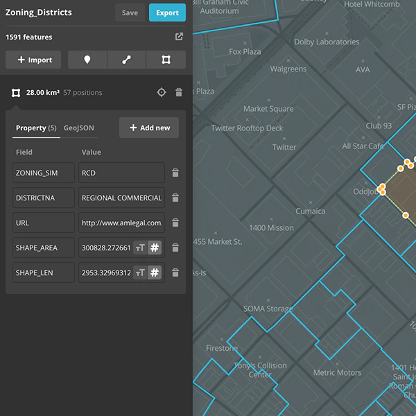 Mapbox Studio dataset editor2016 · mapbox.com · ▲120
Creating and edit geospatial data in your browser

 Map Maker – draw & edit spatial data2025 · chromewebstore.google.com · ▲6
A simple mapping tool right in your browser
 MapHub – A Google My Maps Alternative, Based on OpenStreetMap Data2016 · maphub.net · ▲244
MapHub allows you to create, share and collaborate interactive maps online.
 three-geo – Geographic visualization with three.js2018 · github.com · ▲41
3D geographic visualization library. Contribute to w3reality/three-geo development by creating an account on GitHub.

More life & fun this month
the category →
A free city-building game in your browser. You are the mayor. You know what the city needs. Now get it past the zoning board, the neighbors, the appeals court and the next election.
Life & fun · 3d ago · permit.petercai.com
- IV
Life & fun · 15d ago · tanzaniaeducationproject.org

Turn a phone, tablet or TV into a sign. Type a message and it fills the screen: welcome signs, timers, Wi-Fi passwords and more. No app, no account, free.
Life & fun · 16d ago · bigwords.page

Play a free virtual guitar online with your keyboard or by touch. Slow songs down and see every chord, string and strum. Acoustic, classic, electric and bass.
Life & fun · 10d ago · guitoro.com

Carrier settings from iPhone, Pixel and Galaxy firmware, decoded and compared: APNs, VoLTE, 5G and Wi-Fi Calling per carrier, and what each build changed.
Life & fun · 14d ago · carrierexplode.com

Life & fun · 24d ago · space.bl2.net
Source: Show HN post ↗
Launched alongside, February 2020
the whole month →

- SC
Dev tools · 2020 · grep.app


- PH
Profit Hunt | Discover ideas that make money
Commerce · 2020 · profithunt.co