Dev tools · alternatives · 2026

24 alternatives to Off-Nadir Delta: WebGIS for Sat Data
Browser-Based Satellite Imagery Analysis Platform
Below are 24 products that do a similar job, ranked by how close each is in meaning and then by launch-day votes.
- 1
 Open Data▲17
Access free, valuable, regularly updated satellite imagery.
2023 · app.skyfi.com · its alternatives →
- 2
 Satcat▲363
Analyze and track over 25,000 satellites in real-time
2024 · satcat.com · its alternatives →
- 3

Satellite imagery for dummies. Contribute to plant99/felicette development by creating an account on GitHub.
2020 · github.com · its alternatives →
- 4

Satellites 🛰️ are visible in the night sky, no telescope required, if you know where to look. Find out here.
2019 · james.darpinian.com · its alternatives →
- 5
 Terrapattern▲77
A visual search tool for satellite imagery
2016 · terrapattern.com · its alternatives →
- 6

- 7

I've been working on this project for about 4 years. It began as terrain only because world wide elevation data was publicly available. I then added buildings from OpenStreetMap (crowd sourced) and more recently from Overture Maps data. Some computer vision/machine learning advancements [1] in the past few years have made it possible to estimate tree canopy heights using satellite imagery alone making it possible to finally add trees to the map. The data isn't perfect, but it's within +/- 3 meters of so. Good enough to give a general idea for any location on Earth. Happy to answer…
2024 · shademap.app · its alternatives →
- 8AAAstro App▲291
I really like Stellarium and SkySafari but I felt like these are primarily geared towards exploring the sky but not so much "here are the long list of things I want to see, when can I see them tonight and where". There's also not really a great option I've found that combines sky object planning + location weather details while still being free so I built this. The UI's heavily inspired by NINAs sky atlas + Robinhood. Right now you can: View the altitude chart of objects and 3D view Create lists of objects of interest View the annual max/min daily altitude of an object to find the best…
2024 · astro.sshh.io · its alternatives →
- 9

A "virtual satellite" to map Earth in unprecedented detail
2025 · deepmind.google · its alternatives →
- 10
 EarthGuessr▲192
I built it as a way to practice programming. There are probably much better alternatives out there.
2025 · earthguessr.com · its alternatives →
- 11

High-resolution surface analysis with LiDAR data. Contribute to r-follador/delta-relief development by creating an account on GitHub.
2025 · github.com · its alternatives →
- 12
 ADS-B visualizer▲339
I've created a web app for querying and visualization of ADS-B datasets: https://adsb.exposed/ Source code: https://github.com/ClickHouse/adsb.exposed/ The results significantly exceeded my expectations because the pictures are insanely beautiful, and the data is a treasure trove. It proves many statements that were not certain: - it is feasible to generate tiles by aggregation on a pixel level (instead of hexagons or rectangular grid); - it does not require JPG/PNG tiles - we can transfer raw bitmap data with zstd compression; - it is possible to…
2024 · adsb.exposed · its alternatives →
- 13

Medium-low resolution satellite image platform
2025 · gisstar.online · its alternatives →
- 14

This is a service I've built to provide equirectangular cloud maps of the whole Earth, updated every 3 hours, for free. It's based on infrared and visible light data from EUMETSAT, processed to enhance the clouds and try to reduce the impact of surface temperatures on the final image. I built it because it's surprisingly hard to find these kinds of images in a format that's useful to developers and hobbyists. I was building a 3D ISS tracker and wanted to include live clouds but couldn't find anything good, so I got sidetracked, and here we are.
2023 · github.com · its alternatives →
- 15

Sup HN, So I got tired of bouncing between Flightradar, MarineTraffic, and Twitter every time something kicked off globally, so I wrote a dashboard to aggregate it all locally. It’s called Shadowbroker. I’ll admit I leaned way too hard into the "movie hacker" aesthetic for the UI, but the actual pipeline underneath is real. It pulls commercial/military ADS-B, the AIS WebSocket stream (about 25,000+ ships), N2YO satellite telemetry, and GDELT conflict data into a single MapLibre instance. Getting this to run without melting my browser was the hardest part. I'm running this on a laptop…
Mar 2026 · github.com · its alternatives →
- 16MA
Made a little Artemis II tracker for anyone else who is unnecessarily invested in this mission: https://artemis-ii-tracker.com/ For those of us who apparently need a dedicated place to monitor this mission instead of behaving like well-adjusted people.
Apr 2026 · artemis-ii-tracker.com · its alternatives →
- 17

Real-time Geospatial and Geofencing. Contribute to tidwall/tile38 development by creating an account on GitHub.
2019 · github.com · its alternatives →
- 18

Load a gorgeous satellite image in every new Chrome tab
2014 · chromewebstore.google.com · its alternatives →
- 19
 Cloudless▲72
Deep learning pipeline for declouding orbital satellite pics
2016 · github.com · its alternatives →
- 20
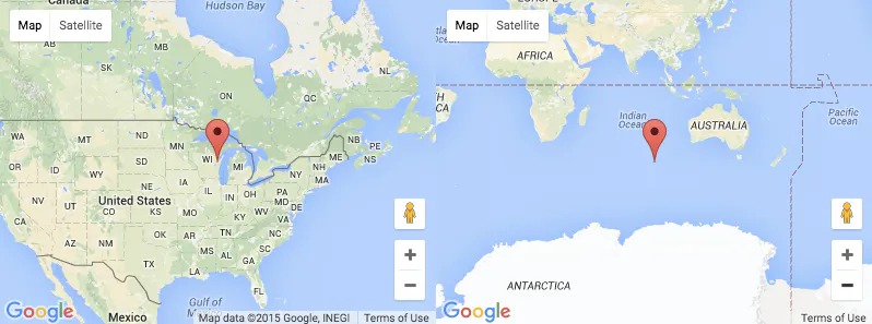 Antipodr▲69
See what's on the opposite side of Earth. (Hint: Not China)
2015 · antipodr.com · its alternatives →
- 21

Real-time Geospatial and Geofencing. Contribute to tidwall/tile38 development by creating an account on GitHub.
2016 · github.com · its alternatives →
- 22

- 23

Quickly view satellite imagery, hyperspectral imagery, and machine learning image outputs directly in your iTerm2 terminal. - daleroberts/bv
2016 · github.com · its alternatives →
- 24

SkyFi delivers satellite imagery, radar (SAR), AIS data, and analytics from the world's top providers in one platform. Search, analyze, and download geospatial data in hours.
2023 · app.skyfi.com · its alternatives →
Also compare
Ranked by how close each launch is in meaning, then by votes. Prices were read from each product’s own site when checked and can change. Refine with your own description →